
Trace a Goleta Street Address
A useful Goleta by-street search begins with the physical address and keeps each record in its proper role. The assessor form can turn a house number and street name into an address candidate and parcel reference. A deed index can then establish a recorded transaction. A permit can show a project, applicant, contractor, or inspection history. A voter channel has stricter access rules, while a directory may offer a dated household clue only when the edition includes the needed street section. None of these sources alone proves who lives at a property today.
- Enter the house number, unit when needed, and street name in the Santa Barbara County Assessor parcel search. Omit the street suffix if the form advises it, and save every plausible result.
- Compare the candidate with parcel or map information. A street sort and the parcel reference help separate duplicate numbers, units, and similar street names.
- Translate the parcel into a deed search. Use the recorder's advertised party, document-title, or document-number fields rather than assuming a street phrase is accepted.
- Use My Voter Status only for an individual's self-check, or follow the County Elections permitted-purpose route for a lawful data request.
- Read a historical street or householder section only where the directory edition contains one, then compare the result with permits, obituaries, or census evidence.
The order matters. Starting with a name can create same-name matches; starting with a parcel gives the address search a stable land key. Moving from address to APN, recorded parties, civic records, and historical sources also exposes gaps instead of filling them with guesses. For a current street question, record the date of each search and distinguish an owner, an applicant, a registered voter, and an occupant.
Goleta Street Records by Address
Street-level research in Goleta crosses city and county custody. The parcel search is address-led, the County Accela system offers address and parcel modes, and the City permit portal adds municipal case and project records. The Clerk-Recorder is different: its advertised routes use party name, document title, or document number. The table keeps those keys visible so an address search does not get mistaken for a direct resident roster.
| Address record | Keeper | Useful key | Access and boundary |
|---|---|---|---|
| Parcel and map search | Santa Barbara County Assessor | House number, unit, street name, APN | Free address form; no verified public owner-name search |
| County permits | County Accela | Address, parcel, permit | Online modes plus County contact; fields and cases vary |
| Goleta permits | City of Goleta | Parcel, case, license, inspection | Portal; registration or login may be required |
| Deeds and maps | County Clerk-Recorder | Party, title, document number | After 1975, 1931-1974 index, and archive route to 1850 |
| Voter channels | County Elections and California Secretary of State | Self-authentication or approved file request | Not an ordinary street roster |
| Historical directories | Libraries and genealogy collections | Name; street section if present | Edition-specific access, not a complete current list |
The APN is the bridge between a physical address and a parcel record, but it does not make all sources equivalent. A permit names a project participant. A recorded document names parties to an instrument. A voter file is purpose-restricted. A directory reflects the edition's coverage. A defensible address entry therefore carries the source, date, and record role beside any address clue.
Goleta Assessor Search Fields
The Santa Barbara County Assessor parcel and address form is a practical insider tip because its actual fields are narrower than generic property-search advice suggests. It accepts an APN or address clues. It does not offer a verified public owner-name search. If a street query fails, the research notes advise omitting Street, Avenue, or Boulevard and trying a partial street name.
| Field | Entry | Required | Format note |
|---|---|---|---|
| Parcel Number | Text | No | Example format: 123-456-789 |
| House Number | Text | No | Use the situs number |
| Unit # | Text | No | Useful for a divided address |
| Street Name | Text | No | Omit the suffix; a partial name may help |
| Sort Results By | Radio choice | Yes | Parcel # or Street |
| Clear | Button | Not applicable | Resets the form |
Use the parcel result as a candidate, not as a final statement about a household. Assessor map sheets are informational, some date to 1960, and the effective-date notation helps judge currency. Legal descriptions and recorded maps are the stronger check when similar addresses appear.
Note: A partial street query and a parcel-by-parcel review are safer than treating one broad text match as the whole street.
Accela Connects Goleta Parcels and Permits
County Accela adds a second address path. Its lookup modes are Address, Parcel Information, and Permit Information. The address form includes a street-number range, direction, street name and type, city, state, segmented ZIP, and country. Look Up and Clear buttons frame the search. The County contact listed for the system is 105 E. Anapamu St., Santa Barbara, California 93101, 805-681-4200.
The County address, parcel, and permit lookup is the source behind the Goleta street-directory image below.
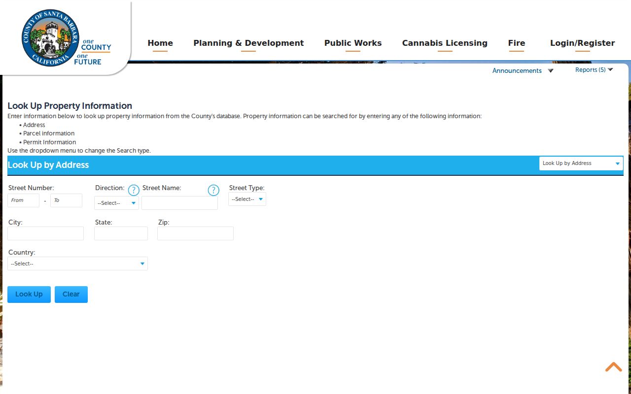
The portal can connect an address to a case or parcel record, but a permit still describes public work, an applicant, a contractor, or an inspection. It does not identify every person connected with the address. Preserve the case number and date, then compare the record with the City portal when the parcel is within incorporated Goleta.
Goleta Permit Files Split at 2002
Goleta incorporated in 2002, so permit research has a custody divide. Newer planning, building, public-works, business-license, inspection, mapping, and issue-report activity may appear in the Goleta permit and license portal. The landing page offers registration and login, and the research could not verify every live search field. Older planning and building evidence may remain with Santa Barbara County, especially for pre-incorporation activity or unincorporated parcels. The City's planning and environmental review contacts provide the documented phone and counter route.
Goleta Planning
805-961-7543
planningcounter@cityofgoleta.gov
Counter Monday and Wednesday, 8 a.m. to noon; virtual hours Monday through Thursday, 8 a.m. to 4 p.m., and Friday, 8 a.m. to noon.
Goleta Building
805-961-7552
buildinggroup@cityofgoleta.gov
Counter Monday and Wednesday, 8 a.m. to noon; virtual hours Monday through Thursday, 8 a.m. to 4 p.m.
Goleta Code Compliance
805-961-7556
codecompliance@cityofgoleta.gov
Use the City route for a code case; use County Accela or a focused public-record request for older evidence.
If a portal does not expose an identifiable file, the City public-record request route can seek an existing record. A request may be inspected or copied under the California Public Records Act, but it does not require the City to create a resident directory.
Recorder Deeds Are Not Street Searches
The Santa Barbara County real-estate records route has two online historical bands. The modern Official Records Search covers after 1975. The separate Santa Barbara historical index covers 1931-1974. The County advertises party name, document title, and document number searches, not a street-address field. Begin with the APN and legal description, then use the address as a clue while following the named parties in each instrument.
Older work continues through the County Historical Archives, deed books, and recorded maps reaching back to 1850. Indexes and copies have different access paths and may involve statutory fees. Do not invent a book, page, consideration, image, or owner field when the live result has not shown it.
The historical recorder index supplies the second Goleta street-directory image. It illustrates the separate historical route, while the records themselves must still be matched to the parcel and document chain.
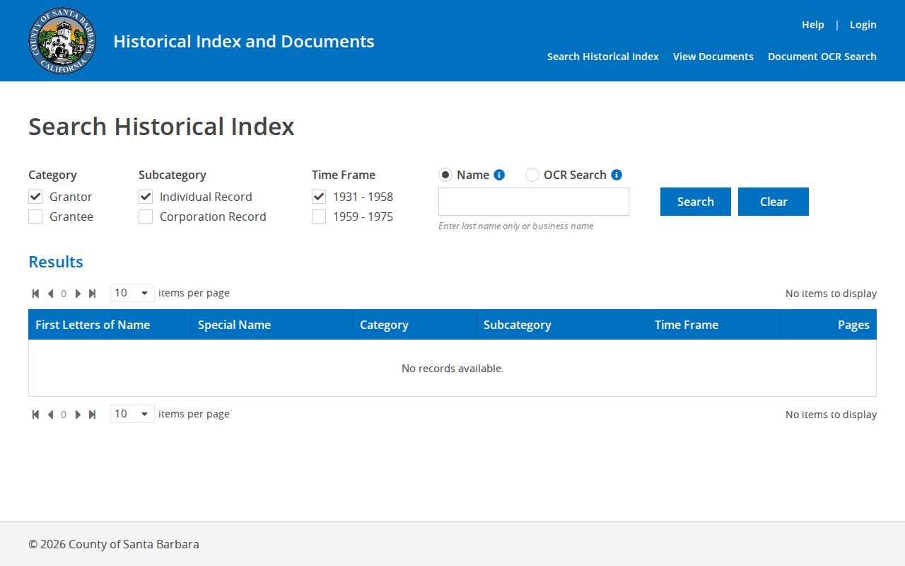
When the question turns from a whole street to the past of one address, the Goleta past residents record trail adds the backward-search sequence without turning deed parties into a list of present occupants.
Note: The 1975 and 1931 cutoffs are switches between record systems, not proof that a parcel had no earlier history.
Goleta Parcel Terms in Plain English
Old maps and modern forms use short terms that can blur the difference between land, mail, and people. These definitions keep a Goleta street directory precise when an address appears in more than one system.
- Parcel
- A mapped unit of land identified by an assessor parcel number. The APN is a bridge to maps and records, not a household count.
- Situs address
- The physical location of the parcel. It can differ from an owner's mailing address or a postal city label.
- Plat
- A recorded map that helps relate lots, blocks, roads, and subdivision descriptions. It supports matching but does not replace the recorded instrument.
- Criss-cross directory
- A reverse directory arranged around a street or address when that edition contains a street or householder section. It is a historical snapshot, not a complete current roster.
Reading a Historical Goleta Street Directory
Selected Polk editions can add a dated address clue, but the verified run is not continuous. Research identifies 1954, 1967, 1968, 1969, 1974, 1983, and 1984-85 editions. Search surname spellings and place labels, then check whether the particular volume contains a street or householder section before treating an address line as evidence.
Compare an appearance, disappearance, spouse or widow notation, occupation, residence, or move with a deed date and a census schedule. “Goleta” in an older volume can describe the wider valley rather than today's city line. The result belongs in a timeline with the edition year and source, not in a claim that every household on a street was listed.
A historical directory is most useful when it answers a narrow question: whether a surname appeared at a place in a named year, whether a street section exists, or whether an address should be searched under an older community label. It cannot fill a missing year by inference.
A Goleta ZIP Is Not a City Boundary
ZIP 93117 reaches beyond incorporated Goleta and includes Isla Vista. That makes a postal match useful for routing mail but weak as a jurisdiction test. A street directory search that starts with a ZIP should confirm the parcel, city district, and municipal boundary before assigning a record to Goleta.
City geography has four districts: Northeast/Fairview, Southeast/Old Town, Northwest/Winchester, and Southwest/Ellwood. The district and address map is a better civic check than a ZIP alone. The same distinction matters for libraries and service areas, which can extend beyond the city while remaining relevant to local history.
Boundary check. Postal identity, situs, APN, service district, and city jurisdiction are separate layers. Keep each label beside the record it describes.
Goleta Voter Data Has a Narrow Street View
My Voter Status is a self-authenticated lookup. Its workflow uses the voter's first name, last name, date of birth, and, when needed, a California driver's license or state ID or the last four digits of a Social Security number. A match can return registration status, residence or registration information, county contact, precinct, districts, poll place, and ballot status as applicable. It does not expose ballot choices and it is not a block roster.
For a permitted election, scholarly, journalistic, political, or governmental purpose, Santa Barbara County provides a voter-registration data request route and the related elections forms. A request identifies the organization, purpose, file or selection, intended users, security controls, and declaration. Elections Code section 2194 keeps ordinary voter data confidential, and section 18109 penalizes knowing unauthorized use. Commercial directory building is not the street-search shortcut.
Note: Inactive voter status can follow returned confirmation mail and does not establish a move date or current occupancy.
What a Goleta Street Directory Leaves Out
A street directory can connect an address to a parcel, permit, deed party, civic district, or dated historical entry. It cannot safely turn those roles into a list of household members. Utility subscribers and delivery records are not public resident lists. DMV personal data is closed under the federal Driver's Privacy Protection Act and California Vehicle Code section 1808.21. California's Safe at Home program and confidential voter registration can also replace or withhold a protected address.
Keep owner, mailing address, applicant, registered voter, and occupant as separate labels. A homeowners' exemption, when encountered through an authorized source, is evidence of a claimed principal residence, not a roster. A record that seems incomplete may reflect a legal limit rather than a search error.
Lawful personal use. Goleta address and street records support family history, property research, civic curiosity, and personal safety awareness. Never use a street directory to stalk, threaten, harass, or intimidate anyone.